
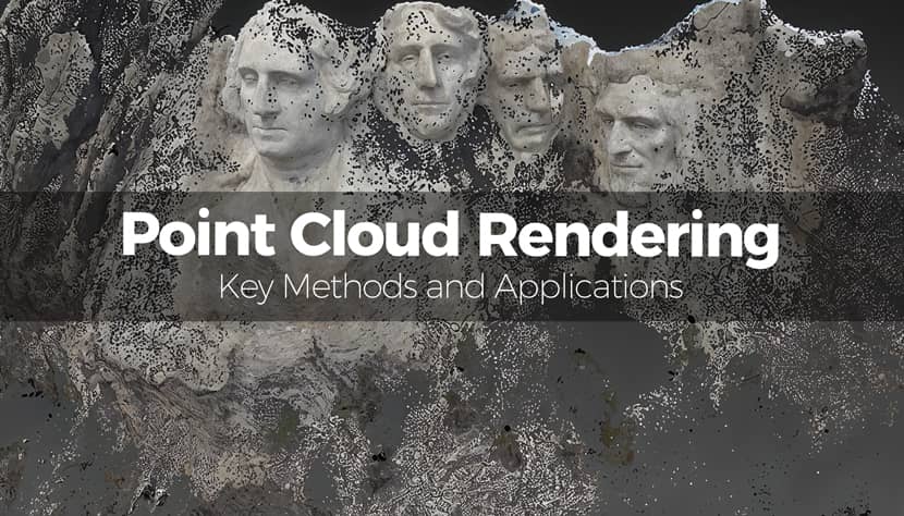
In the evolving world of 3D visualization, point cloud rendering has become an essential technique for interpreting spatial data with incredible precision. Whether it’s for architecture, archaeology, gaming, or industrial design, point clouds provide a rich, detailed view of the real world. Check the article and learn more about Point Cloud rendering method!
This article delves into the fundamentals of point cloud rendering, exploring how it works, which tools and methods are most effective, and where it’s being applied across industries.
What Is a Point Cloud and How Does It Work?
Before diving into applications and tools, it’s essential to understand what a point cloud is and how it's created.
Basic Definition of Point Clouds.
A point cloud is a digital representation of a 3D object or space composed of numerous individual points plotted in three-dimensional space. Each point has coordinates (X, Y, Z) and may include additional attributes such as color, intensity, or reflectivity. Unlike meshes, point clouds don’t define surfaces or edges but instead form a collection of spatial points that suggest shape and volume.
Below a short video by Geospatial World that helps us understand better the term:
To better understand this concept, the video by Holocreators Gmbh offers a great visual breakdown. Swann, a 3D scanning expert, explains what a point cloud is using a real-world laser scan of the Fleetschlößchen in Hamburg. The author highlights how each point contains XYZ coordinates, and often includes color (RGB), orientation, and intensity. He also walks through typical point cloud formats like .XYZ, .PLY, and .E57, and introduces free tools like CloudCompare and MeshLab for viewing and editing. The video is a beginner-friendly guide that visually reinforces the basics covered here.
Technologies for Capturing Point Cloud Data.
Different technologies are used to acquire the data points that form a point cloud. Here’s a look at the most popular methods.
- LiDAR (Light Detection and Ranging): Uses laser pulses to measure distances from a sensor to surrounding objects.
- Photogrammetry: Captures multiple overlapping images and uses triangulation to reconstruct spatial geometry.
- Structured Light Scanning: Projects a pattern of light onto an object and interprets distortions to generate depth data.
- Mobile and Drone Scanning: Combines GPS, IMU, and LiDAR/photogrammetry tools for efficient large-area data capture.
Technologies for Capturing Point Cloud Data.
Creating a usable point cloud involves a multi-step workflow. Let’s break down the key stages.
- Capture: Collect raw data using LiDAR, photogrammetry, or structured light.
- Alignment: Align multiple scans using common reference points.
- Registration: Merge datasets into a single, coherent point cloud.
- Export: Convert to standard formats (.las, .ply, .e57) for use in rendering or analysis software.
A more detailed workflow with multiple well-explained steps has been described by Florent Poux in this video below:
Key Techniques in Point Cloud Rendering.
Once you have your point cloud data, several rendering techniques come into play to bring it to life.
Mesh Reconstruction and Surface Modeling.
One of the first post-processing steps is converting point clouds into surface meshes. This helps transform raw data into usable 3D models for CAD, BIM, or manufacturing.
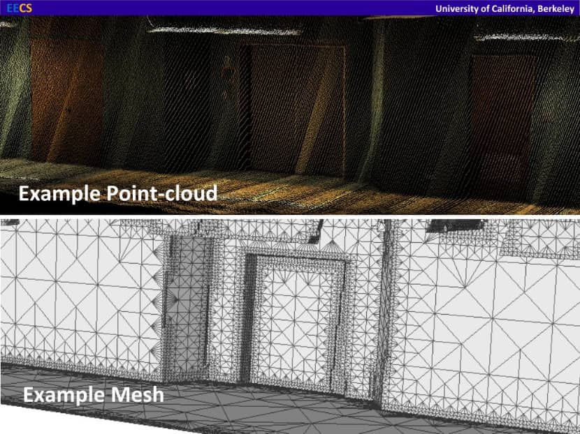
Algorithms like Poisson Surface Reconstruction or Delaunay triangulation are commonly used.
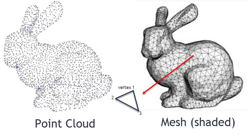
Image by Packtpub.
Real-Time Rendering of Point Clouds.
To interact with point clouds efficiently, real-time rendering engines are crucial. Here's how they manage massive datasets.
Rendering massive point clouds in real time requires powerful engines. Platforms like Unreal Engine, Unity, and WebGL-based visualizers (e.g., Potree) offer support for large dataset rendering with real-time interaction, level of detail (LOD) management, and GPU acceleration.
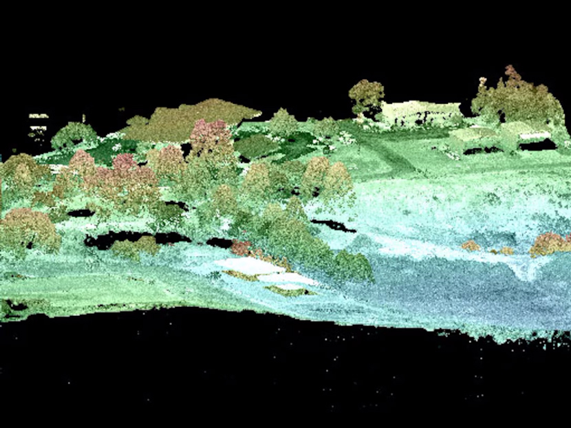
Using Colored Point Clouds for Contextual Accuracy.
Color can make a huge difference in how we interpret point cloud data. Let’s explore how colorization enhances clarity.
Incorporating RGB color or intensity data enhances interpretability. Colorization helps distinguish surfaces and materials, making the model more comprehensible, especially in urban mapping, architecture, and heritage preservation.
Here are visual examples illustrating how colorization enhances clarity in point cloud rendering. These images illustrate how adding color not only makes point clouds visually richer but also significantly improves readability, making it easier to identify objects, segment scenes, and understand spatial relationships in 3D data.
- Colorized LiDAR scan of a landscape or urban scene – vibrant points representing real-world colors improve interpretation of terrain and structures.
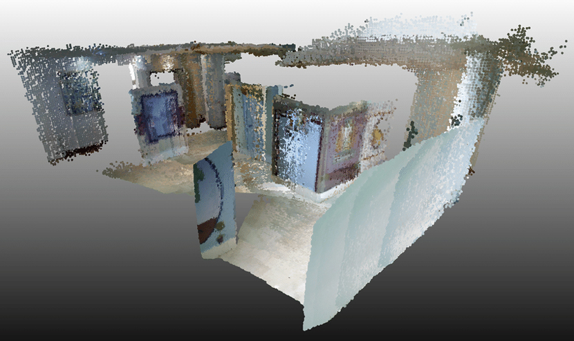
- Indoor colored point cloud – RGB data helps distinguish walls, furniture, and objects in interior scans.
- Color-based classification overlays – visual comparison between raw colorized point data and segmented classification highlights how color aids in automated analysis.
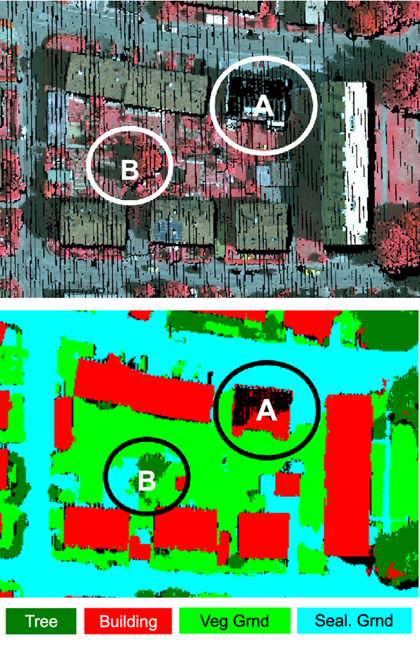
Image by Researchgate. - Kinect-derived colored point cloud – demonstrates real-time capture with color, useful for visualization in robotics and simulation.
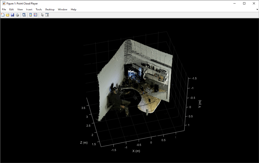
Image by La Mathworks.
Optimizing Point Clouds with Segmentation and Decimation.
Performance matters, especially with large datasets. Optimization techniques help keep things efficient.
To handle large-scale datasets, segmentation splits clouds into logical parts, while decimation reduces point density without compromising critical geometry. This speeds up processing and rendering while ensuring visual fidelity.
Managing and Storing Massive Point Cloud Datasets.
Point clouds can become extremely large. Here’s how to manage, store, and access them effectively.
Cloud-Based Collaboration and Access.
Platforms like NavVis and Cesium offer centralized access and real-time collaboration on massive datasets. Users can annotate, measure, and share point cloud projects through cloud streaming without downloading heavy files.
This video demonstrates NavVis IndoorViewer (now IVION), showing how users can upload, visualize, annotate, and share massive indoor point cloud scans—all through a web-based interface capable of real-time collaboration across teams.
A clear walkthrough of Cesium Ion, this tutorial covers how to upload geospatial datasets, convert them into streaming 3D Tiles, and render them in-browser. It highlights collaborative features like sharing map views and immersive access to massive datasets without heavy local downloads.
Local Storage and File-Based Workflows.
If you're working offline, these formats and strategies will help you store and handle point cloud data efficiently.
For offline work, storing point clouds locally requires efficient file formats:
- .e57: A compact, standardized format with metadata.
- .las: Commonly used in LiDAR workflows.
- .ply: Ideal for colored point clouds.
Compression techniques and proper file organization are essential to avoid performance bottlenecks.
Best Practices for Performance Optimization.
Let’s look at a few smart practices that can make a big difference in speed and usability.
- Use downsampling techniques to reduce resolution while preserving detail.
- Index datasets for faster access.
- Regularly clean and validate data to eliminate duplicates and errors.
This tutorial below, by Sergio Barata, walks you through strategies for optimizing large point cloud datasets, especially for use in Revit. It demonstrates how to:
- Reduce point density in non-essential regions to improve performance.
- Clean up noise and artifacts before importing.
- Export a streamlined, decimated model that maintains visual and spatial accuracy while being much more efficient to process.
Software Tools for Point Cloud Rendering and Editing.
A range of software solutions exist to process, render, and visualize point cloud data. Here are some of the most notable.
Autodesk ReCap and Other BIM-Ready Tools.
Autodesk ReCap excels in converting point clouds into BIM models. It integrates seamlessly with AutoCAD and Revit, offering tools for surface reconstruction, annotation, and export. Other BIM-ready solutions include Faro SCENE and Leica Cyclone.
This video provides a clear, professional demonstration from Autodesk's own team, showcasing how Autodesk ReCap Pro imports raw point cloud data and transforms it into precise BIM-ready models. You'll see the full workflow:
- Importing and aligning laser scan datasets.
- Cleaning, trimming, and cropping noisy regions for accuracy.
- Exporting to .RCP/.RCS formats and seamlessly bringing them into Revit for further architectural modeling.
Cloud Platforms for Streaming and Visualization.
If your workflow depends on accessibility and sharing, these tools might be ideal.
Tools like NavVis IndoorViewer, Bentley ContextCapture, and Cesium ion enable online access to large point clouds. These platforms support mobile viewing, annotations, and integration into digital twin ecosystems.
This overview demonstrates how ContextCapture:
- Processes aerial imagery and LiDAR to generate high-resolution 3D meshes and point clouds.
- Handles large-scale infrastructure and urban models efficiently.
- Enables seamless export to CAD, GIS, and streaming formats for web or desktop use.
Open-Source and Lightweight Solutions.
Sometimes less is more. These lightweight options are powerful and free.
- Potree: WebGL-based open-source viewer ideal for public data sharing.
- CloudCompare: Robust editing and segmentation tools.
- MeshLab: Great for mesh generation and cleanup from point clouds.
In this video below, Florent Poux showcases as an excellent introduction by:
- Demonstrating Potree as a WebGL-based viewer for sharing and inspecting large point cloud datasets online.
- Walking through MeshLab for surface cleaning, mesh conversion, and editing.
- Showing CloudCompare in action for segmentation, clipping, and optimizing point cloud geometry.
Real-World Applications of Point Cloud Rendering.
Point cloud rendering is used across many industries. Let’s explore its real-world applications.
Architecture, Engineering, and Construction (AEC).
In the AEC industry, point clouds have revolutionized how professionals document and evaluate built environments. Using 3D laser scanning or photogrammetry, architects and engineers can capture detailed as-is conditions of existing structures, which are invaluable for renovation planning, retrofitting, and extension design. The resulting point cloud serves as a foundation for accurate measurements and model creation.
Furthermore, point clouds are seamlessly integrated into BIM workflows to identify clashes between architectural and structural components before construction begins. This not only reduces costly on-site errors but also enhances communication among stakeholders. Project managers also rely on point clouds for site monitoring, comparing scan data over time to track progress, verify completed work, and ensure that the project stays aligned with design specifications.
Heritage Conservation and Archaeology.
History meets high-tech. Here’s how point clouds help preserve the past.
Detailed scans preserve the integrity of historic monuments, allowing for virtual reconstructions and minimizing physical intervention.
In this video, heritage and archaeology experts walk through the process of using terrestrial laser scanning and photogrammetry to capture detailed 3D representations of historic sites. You’ll see how these high-resolution scans preserve the physical integrity of cultural assets, enabling digital reconstruction and analysis—without any physical intervention. The footage highlights the dual benefit of:
- Digital Preservation & Interpretation: Collected point clouds serve as archives that can be virtually explored, researched, and shared without disturbing fragile monuments.
- Non‑Contact Reconstruction Techniques: Point cloud data is converted into textured 3D models, supporting restoration efforts and public engagement through virtual tours.
Urban Planning and Infrastructure Monitoring.
Cities are complex systems. Point clouds help model, manage, and maintain them efficiently. City planners use point clouds to simulate traffic, monitor infrastructure conditions, and develop smart city models.
In this Autodesk webinar, urban planners and engineers demonstrate how they import extensive point clouds into InfraWorks and Civil 3D to build interactive city-scale models. The session shows:
- Traffic simulation: layering point clouds with CAD road networks to simulate vehicle and pedestrian flows.
- Infrastructure monitoring: detecting and visualizing structural elements,bridges, streetlights, utilities, within the point cloud.
- Smart-city planning: using dynamic models for real‑time scenario evaluation and decision-making.
It’s a compelling example of a practical “smart city” workflow, integrating point clouds into planning tools, enabling data-rich visualization, analysis, and collaboration.
Manufacturing and Industrial Design.
Precision and speed are everything. Here’s how point clouds benefit industrial workflows.
- Reverse Engineering: Capture the geometry of legacy parts.
- Quality Control: Compare scans against CAD models.
- Prototyping: Evaluate fit and finish before mass production.
Media, Entertainment, and Game Development.
Immersion starts with realism. Let’s look at how point clouds bring digital worlds to life.
Point cloud data from photogrammetry enriches virtual environments for video games and film. Entire sets can be digitized for immersive storytelling. If you want to have a deeper and detailed understanding in photogrammetry process check out our previous article: "Learn To Create 3D Model From Photos".
Advantages of Point Cloud Rendering Across Industries.
The benefits of point cloud rendering are clear. Here are some of the top reasons it’s being adopted worldwide.
Higher Accuracy in Representing As-Is Conditions.
Point clouds excel in capturing exact conditions without assumptions. This minimizes errors in downstream modeling and analysis.
Reduced Time and Costs in Fieldwork.
Efficiency is key. Here’s how point clouds help reduce overhead in the field. Rapid data acquisition reduces the need for revisits. Drones and mobile LiDAR can scan entire sites in hours.
Improved Team Communication Through Visualization.
Better visuals mean better collaboration and here’s how teams benefit. 3D representations make it easier to discuss changes, plan interventions, and share insights across disciplines.
Better Planning with Digital Twins and BIM Integration.
Digital transformation starts with accuracy and that's why point clouds feed into smart planning tools. Digital twins derived from point clouds support simulation, maintenance planning, and IoT integration.
Getting Started with Point Cloud Rendering.
If you’re curious about working with point clouds, the barrier to entry is lower than you might think. To begin:
- Try photogrammetry apps like RealityCapture or Meshroom.
- Explore free viewers like Potree or CloudCompare.
- Test cloud streaming platforms such as Cesium ion.
No matter your industry, starting with sample datasets can help you understand the scope and possibilities of point cloud rendering.
Frequently Asked Questions.
Still have questions? Here are answers to some of the most common queries.
How Are Point Clouds Different from Mesh Models?
Point clouds are a raw representation of spatial data using points, while mesh models use vertices and edges to define surfaces.
Is Photogrammetry the Same as Point Cloud Scanning?
Photogrammetry is a method to generate point clouds using images. It differs from LiDAR, which uses direct laser measurement.
Which File Formats Are Best for Long-Term Use?
Formats like .e57 and .las offer metadata support and industry standardization, making them suitable for archiving.
How Accurate Can Point Cloud Rendering Be?
Depending on the scanning method, sub-millimeter accuracy is achievable. However, environmental factors and equipment quality matter.
Can Point Clouds Be Used on Mobile Devices?
Yes. With modern cloud platforms and mobile-optimized viewers, you can interact with point clouds on tablets and smartphones.
Final Thoughts.
Technology often seems overwhelming at first, complex, fast-paced, and difficult to apply in everyday practice. But when you stumble upon a topic that sparks your curiosity, something changes. You begin to explore, to learn, and eventually, you realize not only how much you enjoy it, but also how valuable it can be in shaping the world around you. Point cloud rendering is one of those fascinating technologies. It blends precision with creativity, and its applications can be found everywhere, from preserving historic monuments to designing the cities of the future.
We hope that this article helped demystify the subject and inspired you to take your next step into the world of 3D data. Whether you’re a curious beginner or a seasoned professional, there’s always more to discover. See you in the next guide!
Kind regards & Keep rendering! 🧡

About the author
Vasilis Koutlis, the founder of VWArtclub, was born in Athens in 1979. After studying furniture design and decoration, he started dedicating himself to 3D art in 2002. In 2012, the idea of VWArtclub was born: an active 3D community that has grown over the last 12 years into one of the largest online 3D communities worldwide, with over 160 thousand members. He acquired partners worldwide, and various collaborators trusted him with their ideas as he rewarded them with his consistent state-of-the-art services. Not a moment goes by without him thinking of a beautiful image; thus, he is never concerned with time but only with the design's quality.
![]()
![]()
![]()
![]()
![]()