
 |
 |
 |
| RebusFarm News | 3D Community News | 3D Film News |
3D models
-
Ray Renders - Download 3D Models Directly from Any Product Website — No Modeling Needed
2025年06月10日(火)
One of the biggest time-consuming tasks is manually modeling custom furniture to match your client’s requests. But what if you could skip the modeling altogether and download 3D models directly from retail websites?
-
VNTANA - Revolutionize Your 3D Workflow With Bulk Upload And Optimize
2025年05月27日(火)
VNTANA is here to streamline your pipeline like never before. Whether you're managing thousands of digital assets or just trying to reduce file sizes without sacrificing quality, VNTANA’s platform is designed to simplify, accelerate, and elevate your workflow!
-
Design Connected - AI-Powered Automation To Organize The Mess
2025年01月24日(金)
For digital artists, designers, and 3D professionals, keeping an ever-growing library of assets organized can feel like a real challenge. Enter Connecter 7 by Design Connected, the latest iteration of their powerful asset management software, now equipped with AI-powered automation to transform chaos into order. Watch the video presentation to stay up-to-date with powerful tools that can transform your workflow and make your creative process smoother!
-
Pivot Studio - Pattern Engine 1.0 for 3ds Max
2025年01月16日(木)
Creating complicated and customizable 3D patterns has always been a challenging task for 3d artists. However, Pivot Studio's new scripted tool, Pattern Engine 1.0 for 3ds Max, promises to transform the process, making it more efficient and enjoyable. Watch the video and try it!
-
Sightseeing Stan - Cinematic Interview Lighting From Basic To Advanced
2025年01月14日(火)
Understanding lighting principles is essential when crafting 3D visualizations with a cinematic touch. Sightseeing Stan's insightful video tutorial serves as an excellent resource for learning how to achieve realistic and dynamic lighting setups. Check out this inspirational video tutorial!
-
Nuno Silva - New AI Generates 3D Models in Seconds
2025年01月09日(木)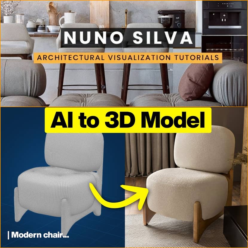
In the ever-evolving world of 3D art, innovation is key to staying ahead. Enter Meshi AI, a promising tool that wants to revolutionize 3D model generation. Nuno Silva recently explored the capabilities of this AI-driven platform, showcasing its potential to transform creative workflows. Check out the video step by step tutorial and stay informed!
-
OF3D Academy - How To Efficiently Organize Your 3D Library
2024年05月23日(木)
Would you like to know how to organize your 3D library and boost your workflow? Watch the video by OF3D Academy and become more productive!
-
3D Models for E-commerce: Enhance Visualization & Sales
2023年10月05日(木)To enhance the shopping experience for their customers, many e-commerce stores rely on 3D rendering product visualization for better product representation. As aesthetics, design, and visual appeal are the needs of the hour, a render farm is a necessary resource for e-commerce stores. In this article, we will walk you through the benefits, importance, and ways you can utilize 3D rendering effectively.

-
Imagine.io - Basic 3d Content Creation Starter Package
2023年09月22日(金)
imagine.io is 3D Made Simple. On-demand 3D content creation platform for Furniture, Home Furnishings & much more.
-
Renderpeople - Introducing Posed People Plus
2023年09月13日(水)
Meet Posed People Plus, the most realistic scans Renderpeople have ever created. Each scan captures even the most delicate details, delivering a lifelike quality that elevates every project. Enjoy the FREE sample!
-
Poliigon - 103 free models, textures, and HDRIs for everyone!
2023年07月24日(月)
Poliigon has announced 103 free assets including several of its most popular textures, models, and HDRIs.
-
Google Maps 3D Models: Benefits, Tools & Downloads for 3D Projects
2023年07月06日(木)Imagine having your town to be seen in your game. As fascinating as it sounds, it is now becoming the reality of most games, movies, and even short movies. Saving pictures from a website is easily achievable for anyone. In today's digital landscape, believing that users can be prevented from saving pictures is unrealistic. Yet, few realize this principle extends to 3D objects. If you have a 3D project coming up, you might want to get help from Google Maps for stunning visuals.
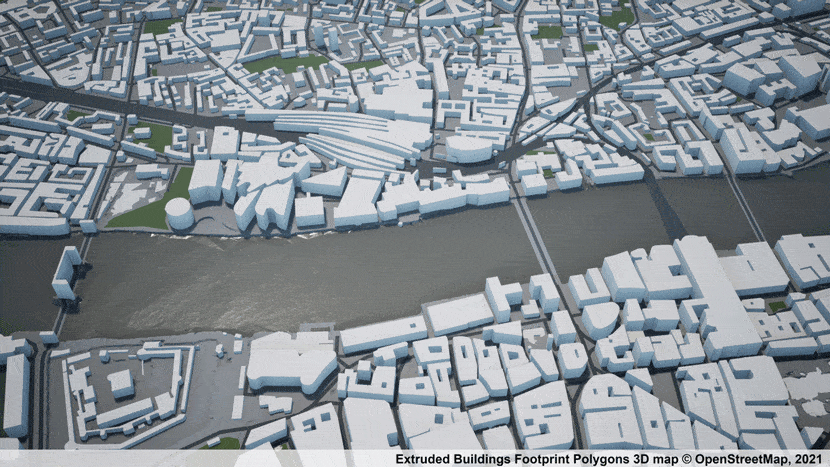 Photogrammetry 3D city model of London: (AccuCities, CC BY-SA 4.0 <https://creativecommons.org/licenses/by-sa/4.0>, via Wikimedia Commons)
 -
ArtWanted! featuring Ruming Cao
2022年12月28日(水)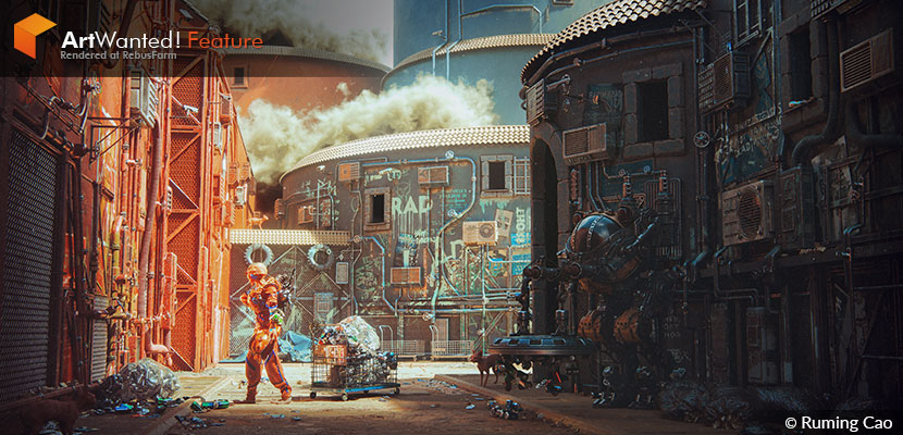
Our final ArtWanted! feature of 2022 sees the return of a familiar face, as Chinese 3D artist Ruming Cao has once again wowed us at the Rebus render farm with another impressive display of his versatile abilities. While his previous works mostly focused on interior design, his latest submission ‘Junkman’ is a scene of high technical complexity and cleverly veiled environmental commentary. Driven by a seemingly unquenchable thirst for knowledge, he is determined in his pursuit of becoming a well-rounded generalist.
In our interview, Ruming discusses stepping out of his comfort zone, reflects on asset creation, and talks about his inspirations and ambitions.
-
Game Dev Academy - Download 3D models from Google Maps & use them in your scene
Thursday, May 26th, 2022: 3D Community News

-
Production Crate - Free 3D castle modular kit
Thursday, February 24th, 2022: 3D Community News

-
Maxtree - 90 free 3D plants models
Thursday, November 18th, 2021: 3D Community News
